|
|
|||||||
|
|
|||||||
|
Think You Can Trust the Government? Just ask an Indian!
The whole object of travel is not to set foot on foreign land; it is at last to set foot on one's own country as a foreign land. ~ G.K. Chesterton
It is good to have an end to journey
towards, but it is the journey that matters in the end
~
I may not have gone where I intended to go, but I think I have ended up where I intended to be. - Douglas Adams |
Bandelier
National Monument
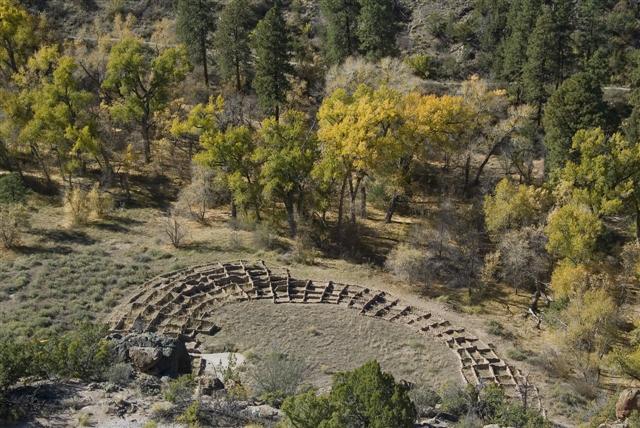
To View a Gallery of this National Park Please Click Here A Brief History of the Park Bandelier National Monument was established in 1916 and covers over 33,000 acres of beautiful central New Mexico. Bandelier is only one component of the the Pajarito Plateau which once covered over a quarter-million acres and was home to the Ancestral Pueblo People. Of this Plateau, there are probably more than nine thousand archeological sites, Bandelier is just the most well known. There is recorded history in this area dating back to 9500 BC with nomadic hunting bands moving in and out of the area in pursuit of large game animals. Around 500 BC, the population of the Rio Grande Valley increased as roving bands settled into a more sedentary lifestyle. This is when early homes which were known as pit houses were built partially underground. In the next thousand years, the native people began to use pottery now that they were staying stationary, and the pit houses were replaced with above-ground structures. Old pit houses were modified into Kivas which were an important part of the ceremonial cycle and culture for the Pueblo tribes. Kivas were the center of the community, not only for religious activates but also for education and decision making.
On October 23, 1880, the people from Cochiti Pueblo brought Adolph Bandelier to Frijoles Canyon for the first time. He revisited the canyon several times over the next decade. In 1893 the land that is now Bandelier National Monument reverted to public domain. Seven years later, the land was withdrawn from homesteading by the General Land Office.
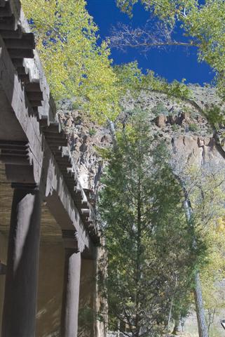
Most of the park you see today was built by the Civilian Conservation Corps who built the main roads into the park, the visitor center and the trails you will walk on which they constructed during the Depression-era of the 1930's. These unique CCC buildings are now recognized as a National Landmark. In 1907 the Lodge of the Ten Elders was built by A.J. Abbott across from the Tyuonyi pueblo. In 1925, George and Evelyn Frey took over the lodge, operating under a contract with the US Forest Service because the park was under their jurisdiction at this time. When the Civilian Conservation Corps came in, a new lodge was built and the Lodge of the Ten Elders was torn down. George Frey left the canyon sometime later, but Mrs. Frey lived here for the rest of her life. She died in 1988, having run the lodge until it closed in 1976. In 1932, the administration of Bandelier National Monument was transferred to the National Park Service. Exploring Frijoles Canyon
We visited Bandelier National Monument in late
October which offered perfect weather with very comfortable
temperatures. Granted the week before, it had snowed in this area
with
From what we heard from the local park officials, I'd stay away during the summer months when the temperatures reach into the 90's and they have to turn people away due to the crowds. They told us that some days there might be a 30-45 minute wait just to find a parking spot! Not my idea of fun! Another thing to make sure you have is plenty of water. Remember this area is dry and hot, they do offer drinking fountains, but they are scattered throughout the park, so make sure you have multiple water bottles in your day pack. Knowing that we were going to be out hiking all day long, Cindy made a huge breakfast so we would be loaded up on carbs and we wouldn't Bonk during our hike. If you ever visit Bandelier National Park, take the hike out of the campground which is called the Frey Trail. It added almost 4 miles to the days hike (2 down, and 2 back up) but it's well worth the extra effort.
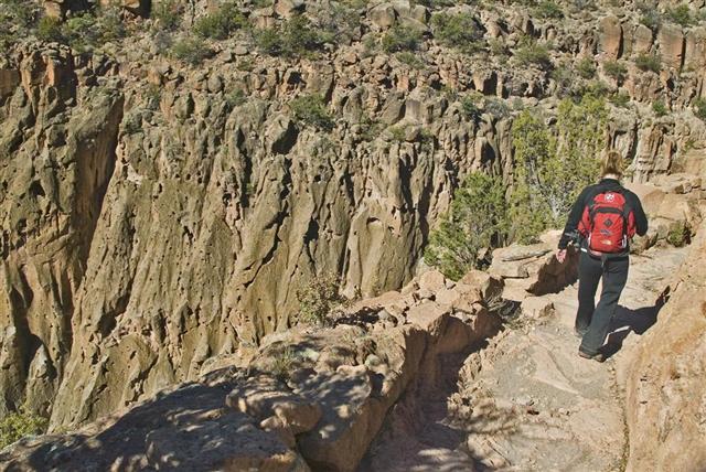
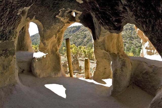
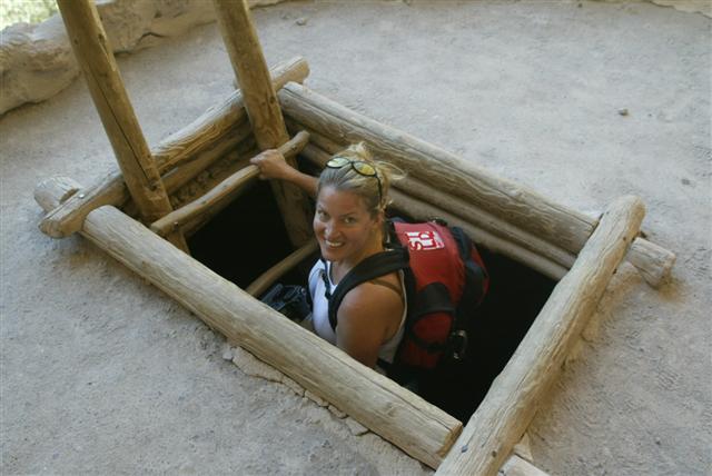
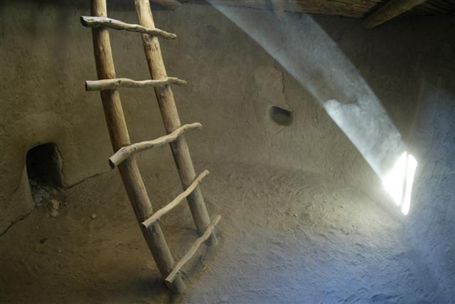
It didn't take long before the sun came up over the surrounding mountain sides and we were peeling off those layers and swapping them out for lighter weight clothes we had brought. If you plan on spending the day here, it might be a good idea to pack a change of clothes for this reason. Remember the area is located at 6,000' in elevation, so any activity will require a little more effort then you're used to if you're like us, and from a flat land state. The upper portion of the Frey Trail starts with scrub brush and is very sandy. Make sure to watch for Tarantulas and snakes as we saw much evidence of their nests. Once you get closer to Frijoles Canyon, the terrain switches to volcanic rock and becomes very steep. We had on a good set of hiking boots and were very glad we did. Flip Flops or anything with heels should be left at home. Plan on doing plenty of climbing and scrambling over rocks, ladders and boulders, so proper shoes should be a must. Cindy's 25lb backpack held the change of clothes and all the food, my 40lb pack held all the camera gear. Being as we were going to spend the entire day exploring this site, I didn't want to leave anything back at the camper, and thank goodness that I brought it all, because we used every bit of it. This park is a photographers dream and we could spend numerous days here just having a ball. The winter months also are better for photographing the ruins as the sun was at a better angle for shadows. I can imagine in the summer months, with the sun directly overhead, you could only be here early in the morning or late in the afternoon to get some of the shots that we were able to get all day long. A good tripod was also helpful to get some shots in the dark Kivas or from inside the Cliff Dwellings.
From multiple Cliff Dwellings, to the Ceremonial grounds this historic pueblo offers, the entire area is just fantastic. We've been at a few parks where you could see everything in an hour, but this wasn't one of them. This site seems like it would be very fun for children of all ages, especially younger teens. We saw numerous children having a ball climbing the many ladders and crawling around in the cliff dwellings. Just keep an eye on them and make sure they don't harm any of these historic ruins.
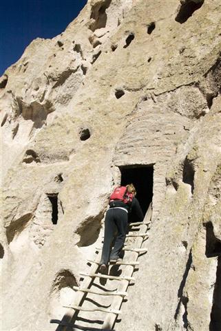
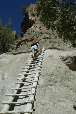
Cindy just walked up to the first ladder, and started climbing. Once at the top, you were rewarded with a view that made the short climb well worth the effort. With a reconstructed Kiva that you can climb down into and a view worth a fortune, we both agreed that these Native Americans knew what they were doing when they settled in this location. It would be a shame to come all this way and miss the Alcove House. Late afternoon is the best time to climb this area as the sun coming in the opening of the Kiva is beautiful.
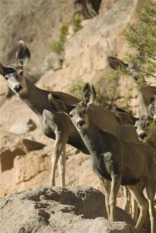
Your walk along the creek on your way to and from the Alcove house is a perfect spot to sit and enjoy a meal. Sitting in the shade of the monstrous Ponderosa Pines, the sounds of the wind blowing through the branches and the flowing water was enough to make me want to move in to one of the Cliff Dwellings. On our walk back, we noticed many Mule Deer grazing in the grass under the trees.
We sat down in a shaded bend in the trail to take a breather and snack on some food, when two young ladies came hiking down from the top. Unlike most of the other visitors, they had decided to hike up and get the Aerial View most miss out on. We sat talking for a few minutes with Elaine and Alana about the surrounding beauty when I spotted a Mule Deer pop its head out from behind a rock.
We sat perfectly still till they got up the courage to jump over the side themselves, which had us all sitting on the edge of our seats for a few minutes. At one point, the two fawns were looking over the edge much higher then where their mother had jumped from; which would have been a 20' leap rather than the 8' drop they finally found.
The other two adult deer who
were standing above us on a ledge just decided to head back up the cliff
side which allowed the two girls to follow the trail
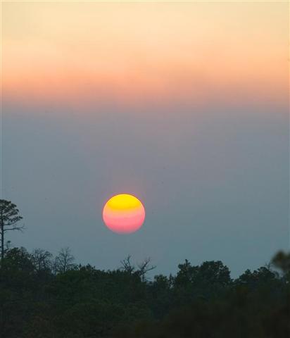
With the camper in sight, my lounge chair sitting under the rising moon, and cold beers flashing through my eyes, this day had been the best one I could remember in months. If the day couldn't get any better, as I was outside sipping on a cold one and cleaning the camera gear, I looked up to notice the sun dipping behind the clouds. The forest service was doing a controlled burn a few mountain passes over and a smoky haze had been lingering all afternoon. When the sun was dropping through the haze, it turned the brightest shade of purple/pink that I've ever seen. What a way to end a already perfect day! Useful Facts on the Area Bandelier National Monument is located 48 miles North West of Santa Fe, New Mexico. From Albuquerque you can reach the park by driving through the Jemez Mountains on New Mexico 4, which is a beautiful drive itself and should have an entire day just for the many sights you'll see along the route. If you don't plan on camping, Los Alamos is located just a few miles away from Bandelier and will have a few different hotels to choose from. The town of White Rock also has a full service grocery store, two gas stations and another hotel. Remember the campground is rustic and does not provide electrical hook-ups for RV's. They do have a dump station and fresh water available, but plan on doing some boondocking. Bandelier is unusual in that there are only three miles of public roads within its 33,750 acres, but there are 70 miles of trails to choose from. This network of trails, both short and long, invites you to explore the park and everything it offers. While hiking around the area, we heard coyotes, saw mule deer, elk and heard many different birds call to us. To View a Gallery of this National Park Please Click Here For more information:
Bandelier National Monument Solar Tips, Fact's and Trick's we've learned while on the road |
||||||
|
|||||||


 Populations
peaked on the Pajarito Plateau early in the 1300's as people from other
areas migrated toward the Rio Grande. Villages grew in size and
most pueblos ranged from 150 to 500 rooms; some were as massive as 1,000
to 1,500 rooms! In 1598, Don Juan de Oñate
(No, not Johnny Deep) founded the first Spanish Colony near the present
day San Juan Pueblo, 25 miles north of here. After the Pueblo
revolt of 1680, some Pueblo people returned to live in Frijoles Canyon,
but then in 1811, Spanish authorities ordered everyone out of the
canyon, stating it had become a den of criminals and outlaws.
Populations
peaked on the Pajarito Plateau early in the 1300's as people from other
areas migrated toward the Rio Grande. Villages grew in size and
most pueblos ranged from 150 to 500 rooms; some were as massive as 1,000
to 1,500 rooms! In 1598, Don Juan de Oñate
(No, not Johnny Deep) founded the first Spanish Colony near the present
day San Juan Pueblo, 25 miles north of here. After the Pueblo
revolt of 1680, some Pueblo people returned to live in Frijoles Canyon,
but then in 1811, Spanish authorities ordered everyone out of the
canyon, stating it had become a den of criminals and outlaws.
 In
the 1890's Edgar Lee Hewett, an educator and archeologist, began
surveying the sites of the Pajarito Plateau, including Frijoles Canyon.
By 1889 Hewett lobbied for the establishment of a notional park on the
Pajarito Plateau to protect the vulnerable archeological sites found
here. After 17 years of relentless effort by Hewett, Bandelier
National Monument was finally established on February 11, 1916 by
President Woodrow Wilson.
In
the 1890's Edgar Lee Hewett, an educator and archeologist, began
surveying the sites of the Pajarito Plateau, including Frijoles Canyon.
By 1889 Hewett lobbied for the establishment of a notional park on the
Pajarito Plateau to protect the vulnerable archeological sites found
here. After 17 years of relentless effort by Hewett, Bandelier
National Monument was finally established on February 11, 1916 by
President Woodrow Wilson. 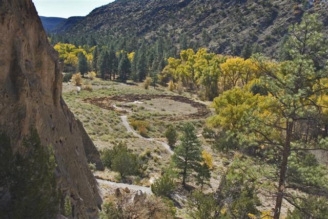 18° temperatures, our visit started with cool morning temperatures
in the mid 40's, and reached into the 70's at mid-day. Except for
a few school busses and one tour bus, the park was very quiet on this
autumn Tuesday.
18° temperatures, our visit started with cool morning temperatures
in the mid 40's, and reached into the 70's at mid-day. Except for
a few school busses and one tour bus, the park was very quiet on this
autumn Tuesday.